LINZHydrographySurveyHydrographicBanks PeninsulaEducationHydrographic surveyAHSCPCertificationHydrographic surveyorScholarshipScienceStudyUniversity of OtagoAustralasian Hydrographic Surveyors CertificationBluffCPHS1DoCECANGisborne District CouncilJimmy van der pauwMount maunganui collegeNautical chartPortsSafetySeaworksStaffStewart IslandStudentSurvey schoolTaranakiTrainingTRANQUIL IMAGEWestern Work Boats#aucklandharbourbridge#bathymetric surveys in remote locations#bestcareerever#declanstubbing#HIPP#hydroscheme#Industryandgovermentworkingtogether#mapping the seabed#mappingthegaps#mobilelaserscanningfromavessel#peoplematter#promotion#publicprivatepartnership#surveynews#talentedpeople#transtasmanpartners#worldhydrographyday2023 Mount Everest ChallengeA career in HydrographyAustraliaAwardBack scatterBen hubbardBill dayBruce WallenCAT ACharityCoastalCoastal engineeringCollaborationCommunityComplianceCongratulationsRyanCPHS Level 1 or 2CPHS2CPHSL2CycloneDeclan stubbingDeerDevelopment in the Bay of PlentyDMLDMLScholarshipDolphinsEmergencyFederated States of MicronesiaFeesFieldworkFire fightingFSMFutureLeadersGabrielleGeospatialGeospatial CouncilGisborneGreg coxHSEHydrographic Survey in SamoaHydrographic surveying on a jet skiHydrographic surveyorsHYPLANIHOJasmin McVeighKate downesKevin smithLand Information New ZealandLaser scanning super structuresLife jacketsLive for MoreMan over boardMarineMauaoMount MaunganuiMulitbeamMultibeamNapierNautical chartingNew PlymouhtNew ZealandNew Zealand Certificate in Hydrographic SurveyingNorthportOIOpen DayPacificPlay hardPohnpeiPohnpei surf and Dive ClubRelaxationRemote vessel survey New ZealandRescureRetirementRiver surveysRNZNSafety of navigationSally coxSand wavesScholarshipAwardSchoolsSea SurveyorSinglebeamSpatial Hydrography Award 2022StudentsSurvey and spatialSurvey requestSurveyingSurveying a shallow pondSurveying sediment pondSurveyorSurvivalTatai Aho Rau LEARNZTeachersTeamTonkin & TaylorVirtual Field TripWater columnWet drillsWhite pointer sharkWomenWork hardYouthYouthInScience
TAGS

Gisborne Survey Open Day

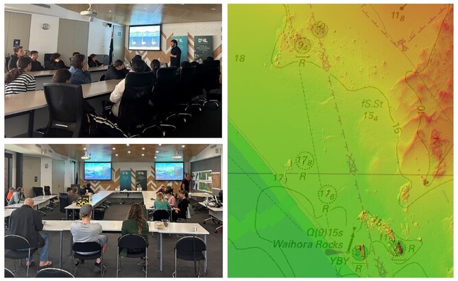
Gisborne District Council, LINZ and Discovery Marine (DML) recently held an open day to raise awareness of the Approaches to Gisborne Hydrographic Survey (HS76) currently underway in Turanganui-a-Kiwa/Poverty Bay, New Zealand.

Kevin, Jimmy and DML’s Surveyor In Charge, Bevan Waller attended along with about 50 people from around the region, including two school groups from Whangara School and Gisborne Boys High School. It was fantastic to see huge interest from the next generation of leaders on what is happening in their local marine environment and hydrography as a career.  

A big thank you to Paul Murphy, Gene Takurua and Oliver Vetter from Gisborne District Council as well as Annette Wilkinson, Bradley Cooper and Stuart Caie from LINZ, for helping to coordinate the day.

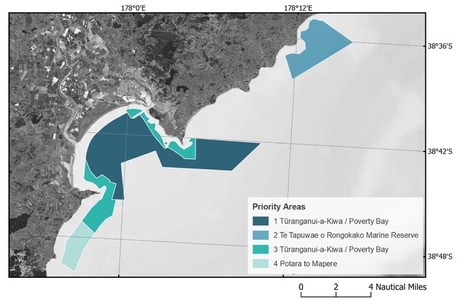
The Approaches to Gisborne Hydrographic Survey area covers over 100km² of seabed which includes the Te Tapuwae o Rongokako Marine Reserve. Hydrographic data captured between the 5m and 80m depth contour will be used to update nautical charting products and provide valuable seabed information.

The DML survey team are juggling periods of rough weather and large swells which are a common occurrence in one of New Zealand’s premier surfing regions. Fieldwork for the survey is anticipated to finish in late November with the final deliverables being provided to LINZ in May 2024.

The Approaches to Gisborne Hydrographic Survey is part of a larger hydrographic survey programme being conducted by LINZ called HYPLAN. For further information on the New Zealand national hydrographic survey programme check out Mapping Aotearoa's Seafloor

If you would like to suggest areas for future hydrographic surveys, submit your interest to LINZ using this clever LINZ Hydrographic Survey Coordination Tool