BACKSCATTER & WATER COLUMN DATA
> DATA TO SUPPORT SCIENCE
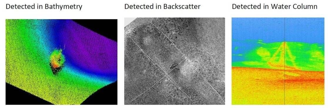
Backscatter and water column data can be logged simultaneously when gathering bathymetry using Multibeam Echo Sounders (MBES).
Backscatter data provides information on the ‘hardness’ of the sea floor and is used to differentiate between different types of sea floor, such as hard rock or soft sediment. The data provides information on the sediment grain-size and sea floor roughness. These measurements can be used to characterise the environment (or habitat) where marine fauna live, and as such can be used to explain spatial patterns of sea floor biology and biodiversity at continuous scales.
Water column data enables 3-D mapping of fish schools and other mid-water marine organisms, assessing biological abundance, species identification, and habitat characterization. The data is also useful for mapping the heights of wrecks, underwater fresh water seeps, gas and oil seeps.
Discovery Marine uses purpose built survey vessels and vessels of opportunity, fitted with MBES, to gather both backscatter and water column data. The final products reveal the diversity and distribution of marine habitats and serve as a useful tool in marine management.
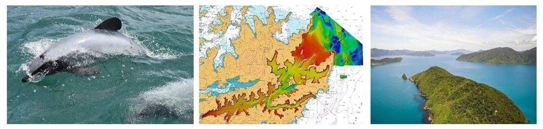
QUEEN CHARLOTTE SOUND | CASE STUDY
F I E L D W O R K D U R A T I O N : 9 MONTHS
C L I E N T : LAND INFORMATION NEW ZEALAND
BACKGROUND
Queen Charlotte Sound / Tōtaranui and Tory Channel / Kura Te Au, separated by Arapawa Island, are the two shipping routes from the Cook Strait to Picton Harbour. Queen Charlotte Sound / Tōtaranui itself is a long, heavily indented, deep inlet located on the North coast of the South Island. The area is subject to heavy gusts coming off high land and from mountain gullies during strong winds in Cook Strait.
Queen Charlotte Sound/Tōtaranui and Tory Channel/Kura Te Au are represented on charts NZ 463 & NZ 615 at a scale of 1:100,000, on NZ 6153 at a scale of 1:36,000. Picton Harbour and the entrance to Tory Channel/Kura Te Au are also represented on NZ 6154 at a scale of 1:10,000 and 1:10,000 (Picton Wharves at 1:3,000).
The area has large extents of the seabed which were last surveyed in 1942-43.
REQUIREMENT
Marlborough District Council (MDC) and LINZ worked collaboratively with NIWA and Discovery Marine to carry out a comprehensive seabed survey of Queen Charlotte Sound/Tōtaranui and Tory Channel/Kura Te Au. The objective of this project was two-fold; the delivery of the validated data to be used to update the existing charts; and the delivery of data essential to ensure sustainable management of natural resources in the Marlborough Sounds. The primary objectives were:
Hydrography
1. The delineation of all low water drying rocks and islets; and
2. Full area search to locate and determine the least depths over significant bathymetric features, known shoals/reef areas and any listed dangers.
Science
1. Accurate characterisation and mapping of seabed habitats;
2. Benthic terrain modelling to classify habitats or ecosystems;
3. Identification of biogenic (or ‘living’) habitats important for biodiversity.
CHALLENGES
The approaches to Queen Charlotte Sound and Tory Channel presented its own unique environmental challenges. The area is subject to high tidal flows resulting in eddies, rips and over falls. Tory Channel has large areas of kelp along the coast which experiences very high seasonal growth rates over a 12 month period. The large degree of marine wildlife, swift currents, complex tidal flows, kelp, fog and floating logs from logging activities made for a challenging environment to operate vessels and survey/sampling/photographic equipment. In some areas data acquisition windows were limited to a matter of hours and then only on extremely fine, calm days and travelling in one direction.
Another key challenge was balancing the demands of stakeholders in the quest for good quality science and nautical charting data for research and completely different end products.
SOLUTION
NIWA and DML provided a two vessel solution utilising a Kongsberg EM2040 MBES and a Kongsberg Geoswath Interferometric sonar to acquire bathymetry, backscatter and watercolumn data.
The EM2040 gathered bathymetry, backscatter and water column data in depths greater than 5m while the Geoswath was used to capture backscatter in depths less than 5m. Watercolumn and backscatter data combined with seabed/video sampling at designated sites was carried out to support NIWA's seabed habitat mapping objectives.
OUTCOME
The survey of Queen Charlotte Sound / Tōtaranui and Tory Channel / Kura Te Au was the largest nautical charting/science survey undertaken in New Zealand waters. The results of the survey will provide a new dataset for LINZ to update the charts in areas last surveyed in 1942-43. They will also provide MDC with a significant baseline dataset to monitor environmental changes in the Sounds and will provide a valuable science data set for future research.