LINZHydrographySurveyHydrographicBanks PeninsulaEducationHydrographic surveyAHSCPCertificationHydrographic surveyorScholarshipScienceStudyUniversity of OtagoAustralasian Hydrographic Surveyors CertificationBluffCPHS1DoCECANGisborne District CouncilJimmy van der pauwMount maunganui collegeNautical chartPortsSafetySeaworksStaffStewart IslandStudentSurvey schoolTaranakiTrainingTRANQUIL IMAGEWestern Work Boats#aucklandharbourbridge#bathymetric surveys in remote locations#bestcareerever#declanstubbing#HIPP#hydroscheme#Industryandgovermentworkingtogether#mapping the seabed#mappingthegaps#mobilelaserscanningfromavessel#peoplematter#promotion#publicprivatepartnership#surveynews#talentedpeople#transtasmanpartners#worldhydrographyday2023 Mount Everest ChallengeA career in HydrographyAustraliaAwardBack scatterBen hubbardBill dayBruce WallenCAT ACharityCoastalCoastal engineeringCollaborationCommunityComplianceCongratulationsRyanCPHS Level 1 or 2CPHS2CPHSL2CycloneDeclan stubbingDeerDevelopment in the Bay of PlentyDMLDMLScholarshipDolphinsEmergencyFederated States of MicronesiaFeesFieldworkFire fightingFSMFutureLeadersGabrielleGeospatialGeospatial CouncilGisborneGreg coxHSEHydrographic Survey in SamoaHydrographic surveying on a jet skiHydrographic surveyorsHYPLANIHOJasmin McVeighKate downesKevin smithLand Information New ZealandLaser scanning super structuresLife jacketsLive for MoreMan over boardMarineMauaoMount MaunganuiMulitbeamMultibeamNapierNautical chartingNew PlymouhtNew ZealandNew Zealand Certificate in Hydrographic SurveyingNorthportOIOpen DayPacificPlay hardPohnpeiPohnpei surf and Dive ClubRelaxationRemote vessel survey New ZealandRescureRetirementRiver surveysRNZNSafety of navigationSally coxSand wavesScholarshipAwardSchoolsSea SurveyorSinglebeamSpatial Hydrography Award 2022StudentsSurvey and spatialSurvey requestSurveyingSurveying a shallow pondSurveying sediment pondSurveyorSurvivalTatai Aho Rau LEARNZTeachersTeamTonkin & TaylorVirtual Field TripWater columnWet drillsWhite pointer sharkWomenWork hardYouthYouthInScience
TAGS

Mobilising for LINZ Hydrographic Surveys HS70 & HS69

For DML’s 21/22 summer field season we have partnered with Western Work Boats (WWB) to deliver Hydrographic Surveying services to Land Information New Zealand (LINZ).  This year’s HYPLAN priority areas for survey include the Banks Peninsula and Bluff and Stewart Island Hydrographic Surveys.  The surveys will be completed over the next 6 months and will deliver new data for nautical charts in both regions.

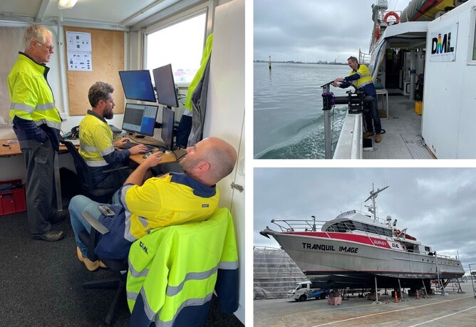
DML reached a significant milestone in preparation for the surveys this week completing mobilisation of WWB’s 23m vessel TRANQUIL IMAGE.  DML have installed a new Universal Sonar Mount (USM) MegaTower, Teledyne RESON T50 MBES, Applanix POSMV Wavemaster and AML Sound Velocity sensors along with QPS Qinsy and Qimera software for acquisition and processing.  Fit out and dimensional control were complete at DML’s home port of Tauranga with sea trials and survey system shakedown currently underway.

Mobilisation is a full team effort with everyone pitching in, even to sew new curtains for the onboard survey office!