New Zealand Ports Benefit from National High-tech Seabed Survey
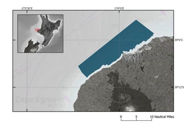
In New Zealand, high-tech seabed surveying of the approaches to Port Taranaki began this week. The survey area extends along the coast from Ōkato to Waitara and approximately 7km from the shore.
The survey is part of the Land Information New Zealand (LINZ) annual work programme to update New Zealand’s nautical charts for commercial and recreational mariners. LINZ Manager Hydrographic Survey Stuart Caie says the data gathered during the survey can be used in other ways to benefit the Taranaki region.
“While our primary goal is safety of navigation, the data collected can also be used for marine science and environmental management. We have been working with Port Taranaki and Taranaki Regional Council to identify these opportunities,” says Mr Caie. Any hazards identified during the survey will be notified through LINZ’s fortnightly Notices to Mariners.
Detailed 3D Seafloor Maps
Specialist marine survey company Discovery Marine Ltd (DML) has been contracted to undertake the Taranaki survey. They will be surveying up to 100m deep in some places to create detailed 3D maps of the seafloor using their vessel MV Sea Surveyor and back-up vessel Tupaia. The survey does not include offshore seismic or geophysical surveying, and the echosounders on board the vessels are very low power and unlikely to have any impact on marine mammals.
Port Taranaki head of operations Ashley McDonald says the work will give the many users of the Taranaki coast important, up-to-date electronic information about the seabed and water depth. “LINZ surveys are in high demand across New Zealand, so we are very fortunate that Port Taranaki and the Taranaki coastline has been chosen as the next location for this work,” Captain McDonald says.
“The electronic data and charts resulting from the survey will be extremely beneficial to the port, visiting vessels, commercial and recreational fishing boats and other users of the coastline, giving them reliable information that will help them navigate the area safely.”
Accurate Water Depth Information
Port Taranaki senior pilot Neill MacKean says the information will particularly benefit foreign vessels. “The seabed changes over time, so the updated data will be of importance for foreign vessels dropping anchor safely and securely. It will also provide accurate water depth information, which will give vessels added confidence when approaching Port Taranaki.”
Captain McDonald asks commercial and recreational boat users to be aware and to keep clear of the survey vessel while it is operating. “Offshore, the work will be carried out 24 hours a day, while surveying will be carried out during daylight hours closer to shore and in the harbour,” he says.
The Taranaki survey depends on weather conditions but is expected to be completed in early 2021 with data delivered by July 2021.
Once the data has been captured and processed, it will be made freely available through the LINZ Data Service.
Updated charts will also be available through the free NZ ENC Service.
 Map of LINZ hydrographic survey area off Taranaki coast. (Courtesy: LINZ)

