NAUTICAL CHARTING SURVEYS
> Comprehensive hydrographic surveys that meet internationally recognised standards for safe ship navigation
In New Zealand, Land Information New Zealand is tasked with keeping our nautical charts current, to ensure safe ship navigation around New Zealand's busy coastline. Port authorities undertake regular hydrographic surveys to monitor and manage adequate under keel clearance within ports.
Delivering a hydrographic survey which meets the needs of nautical charting, as well as providing a base line coastal data set for marine science, is no mean feat! Depending on the complexity of a survey, it can involve between 50 - 80 days of vessel operations just to gather the data, working long days.
In addition to this, it can take upwards of 3-4 months to complete the analysis and reporting phase. During a hydrographic survey strong emphasis is placed on collecting precise depth measurements (bathymetry), seafloor backscatter, water column data, positioning of the shoreline, tides, currents, seabed and submerged obstructions - all features that may influence safe ship navigation and coastal zone coastal management.
The surveys may use a variety of sensors/techniques including Single Beam Echo Sounders (SBES), Side Scan Sonar, Multibeam Echo Sounders(MBES), Sound Velocity Profilers, temperature & salinity sensors, sediment sampling, Acoustic Doppler Current Profiler (ADCP), Mobile Laser Scanning (MLS), underwater photography/video, drone photography, motion senors and RTK/WAGNSS positioning. Discovery Marine undertakes hydrographic surveys using vessels ranging in size from 5m for inshore shallow-water surveys, to larger vessel for off-shore deployments.
There is considerable investment required in state-of-the-art technology and platforms. Our teams operate in challenging environments, where they encounter rocky coastlines, swell, changeable weather and remote locations with extended periods away from home.
DML is one of only two panel providers approved to undertake regular hydrographic surveys for nautical charting.
We are also the only New Zealand owned company, approved to provide these services to the Royal Australian Navy.
DML personnel hold IHO Cat A and CPHS Level 1 Certifications; mandatory for meeting Land Information New Zealand and Royal Australian Navy requirements. Our senior hydrographic surveyors have upwards of 15 years experience delivering complex projects and are extremely proficient mariners. This combined skill set is both scarce and highly-valued.

EASTERN BAY OF PLENTY | CASE STUDY
F I E L D W O R K D U R A T I O N : 72 D A Y S
D A T E : A U G 2 0 1 8 - J A N 2 0 1 9
C L I E N T : L A N D I N F O R M A T I O N N Z
BACKGROUND
Land Information New Zealand (LINZ), is New Zealand's Hydrographic Authority. LINZ is responsible for acquiring quality bathymetry to produce official nautical charts to aid safe navigation in New Zealand waters and certain areas of Antarctica and the South-West Pacific.
LINZ don’t actually gather bathymetry directly, but instead contract two specialist New Zealand based hydrographic surveying companies through a panel of provider arrangement, to do this for them. Discovery Marine is one of the approved providers of this critical service.
In 2017 LINZ released HYPLAN, a risk assessment study undertaken to assist with prioritising the programme of work required to update New Zealand's nautical charts.
The Eastern Bay of Plenty was identified as a key survey priority area within HYPLAN.
REQUIREMENT
Undertake a comprehensive hydrographic survey of three areas within the Eastern Bay of Plenty, including the East Cape, Whakaari/White Island and Moutohora/Whale Island.
SOLUTION
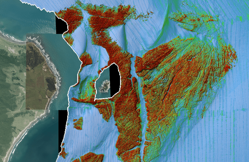
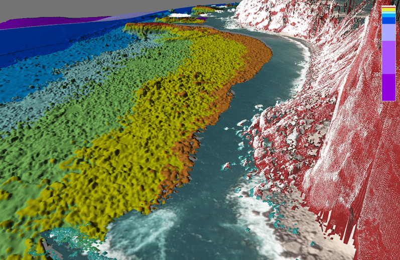
DML undertook the survey using its high resolution Multibeam Echo Sounder (MBES). In addition a vessel mounted Mobile Laser Scanner (MLS) System was used to capture point cloud data of the coastline and topography was also collected using aerial photogrammtry from a drone flown off the survey vessel. The full project took 72 days of fieldwork to complete and a further 2500 person hours to fully process and render the survey deliverables ready of chart production.
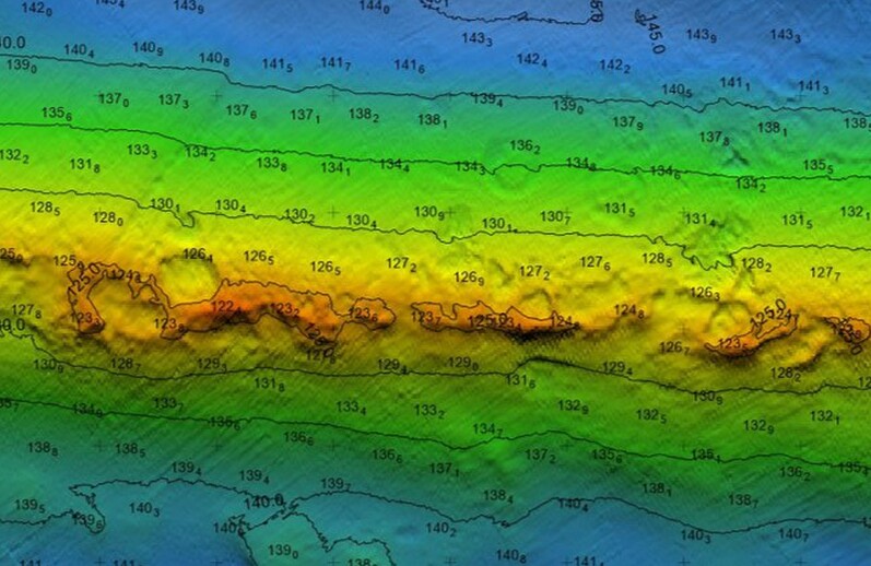
OUTCOME - EAST CAPE
Geologic pock marking was discovered on a rocky ridge (40 - 60m in diameter in depths of 120 - 150 metres).
Large sand waves were also identified covering an extensive area (9km x 2.5km).
Both sets of features were clearly evident in the high resolution bathymetry and seafloor back scatter products.
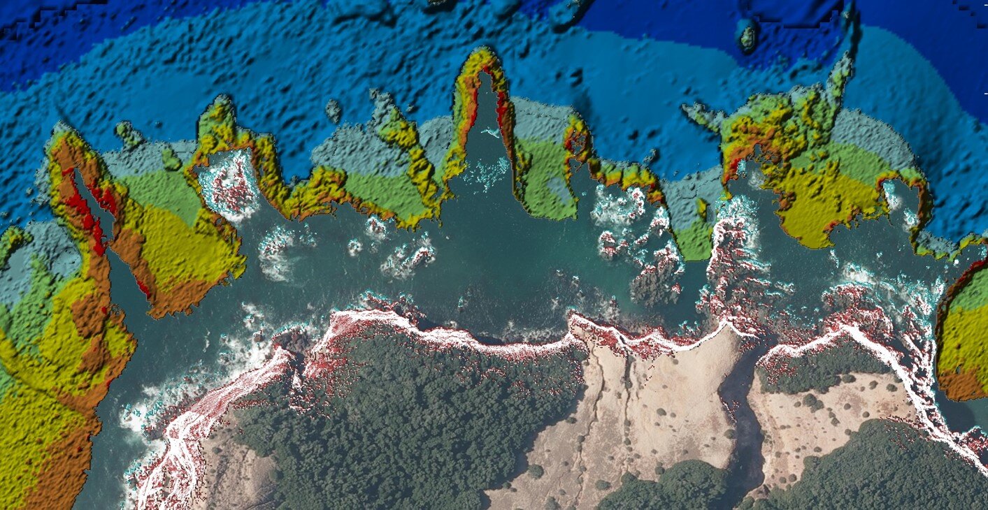
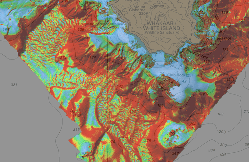
OUTCOME - WHAKAARI / WHITE ISLAND
The survey's back scatter and bathymetry data uncovered extensive lava flows, a complex inter-tidal reef structure and submerged cliffs and underwater canyons. Importantly, a previously uncharted pinnacle was identified outside the 50 metre depth contour at a depth of 3.3 metres.
The multibeam and mobile laser scanning data was combined to provide a data set that will aid with identifying coastline features.

OUTCOME - MOUTOHORA / WHALE ISLAND
Volcanic vents and springs were uncovered on the south side of the island and were evident in the water column and bathymetry data.
The wreck of FV Boston Seafire a 37metre fishing vessel that was scuttled 2008 was also clearly delineated as a significant bathymetric feature.


